Attitude and Azimuth Integrated Navigation System
| Min. Order: | 1 Set/Sets |
|---|---|
| Payment Terms: | T/T |
| Supply Ability: | 500sets/year |
| Place of Origin: | Hubei |
Company Profile
| Location: | Wuhan, Hubei, China (Mainland) |
|---|---|
| Business Type: | Manufacturer |
| Main Products: | Fiber Optic Gyro, Laser Range Finder, EO/IR (electro-optic) Thermal Imaging Tracking System, Thermal Imaging Camera |
Product Detail
| Model No.: | AINS-10 |
|---|---|
| Means of Transport: | Air |
| Brand Name: | JOHO |
| Production Capacity: | 500sets/year |
| Packing: | standard packing |
| Delivery Date: | 4 week |
Product Description
Attitude and Azimuth Integrated Navigation System AINS-10
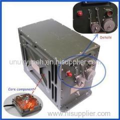
Featured with independent of outside information, excellent concealment, strong anti-interference, all weather operations, inertial navigation system is a complete autonomic navigation system which could provide diverse navigation parameters. However, its output error is accumulated along with time. Global position satellite (GPS) has higher navigation accuracy, but it is easy to be interfered, suffered from discontinuous output and incomplete output information etc. In order to integrate the advantages of these two navigation methods and effectively improve product performance, as well as strength product's reliability, availability, environment adaptability and dynamics, we utilizing multi-sensor data fusion technology to combine satellite positioning, orientation and inertial measurement, and release new attitude and position integration navigation system.
Application
Aircraft flight control and navigation
Ship-borne & vehicle-borne navigation system
Inertial stability control system
E-traffic measurement system
Industrial & agricultural measurement and application
System features
High accuracy, no accumulated error, short starting time;
Keep higher attitude heading accuracy while satellite signal suffered from jamming;
Utilizing dual GPS carrier measurement technology to precisely calculate heading value. Heading accuracy depends on the length of two GPS baseline. Longer baseline, higher directional accuracy.
Technical Specification
Range | |
Heading | 0~360°, |
Pitch angle | 90° |
Roll angle | 180° |
Position accuracy | 50px+1ppm |
Data | |
Output frequency | 100Hz |
GPS data refresh rate | 5Hz |
Data storage ability | Storage system able to continuous working 8h |
Environment parameters | |
Working temperature | -40℃~+60℃ |
Storage temperature | -45℃~+70℃ |
Humidity | 95% (30℃) |
Vibration | 5g (20Hz~2kHz, random), 30min |
Shock | 30g (11ms, half-sine wave, 3 times for each axis) |
Salt spray | Meet GJB150 standard for ship cabin usage |
Reliability | |
MTBF | 2000h |
Continuous working time | ≥12h |
Physical parameters | |
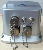
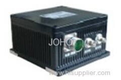
System weight | ≤4.5kg (excluding antenna and feeder line) |
Physical dimension | 170mm×160mm×166mm |
Power supply | |
Power supply | 10-32VDC, 26W, (self Li-on battery able to work continuous 8h) |
Fiber gyro | |
Null bias stability | 0.5°/hr (1σ) |
Null bias repeatability | 0.5°/hr (1σ) |
Random walk coefficient | 0.05°/√hr |
Scale factory non-linearity | 100ppm (1σ) |
Scale factory repeatability | 100ppm (1σ) |
Dynamic range | ±300°/s |
Quartz accelerometer | |
Bias | <3mg |
Current scale factor | 1.2±0.15 mA/g |
Second-order nonlinear coefficient | <50μg/g2 |
Scale factor/ Temperature coefficient | <30 ppm/℃ |
Bias month stability | <50μg |
Scale factor/month stability | <30 ppm |
Bias temperature coefficient | <±50μg/℃ |
Shock | 30g 11ms 1/2sin |
GPS | |
Positioning & orientation time | |
Positioning time typical value | ≤45s |
Orientation time typical value | ≤60s |
Reacquisition time | <5s |
Positioning & orientation accuracy | |
Heading accuracy | 0.1° (length of baseline 2m) |
Pitch angle | 0.2° (length of baseline≥2m |
Position accuracy | 2m CEP autonomous, no SA RTK 50px+1ppm |
Velocity accuracy | 0.02m/s |
Timing accuracy | 50ns |
Dimension Drawing