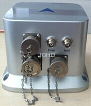
Fiber Optic Vertical Gyro Attitude and Azimuth Integrated Navigation System
| Min. Order: | 1 Set/Sets |
|---|---|
| Payment Terms: | T/T |
| Supply Ability: | 500sets/year |
| Place of Origin: | Hubei |
Company Profile
| Location: | Wuhan, Hubei, China (Mainland) |
|---|---|
| Business Type: | Manufacturer |
| Main Products: | Fiber Optic Gyro, Laser Range Finder, EO/IR (electro-optic) Thermal Imaging Tracking System, Thermal Imaging Camera |
Product Detail
| Model No.: | AINS-20 |
|---|---|
| Means of Transport: | Air |
| Brand Name: | JOHO |
| Production Capacity: | 500sets/year |
| Packing: | standard packing |
| Delivery Date: | 4 week |
Product Description
Attitude and Azimuth Integrated Navigation System AINS-20
Employing high accuracy FOG, Q-flex accelerometers, dual-frequency GPS position & orientation system, barometric altimeter and advanced integration navigation and attitude measurement algorithm, the performance of AINS-20 has been dramatically improved. Combining built-in high accuracy IMU (inertial measurement unit) with satellite, it could output high accuracy position, speed, attitude, angular speed and acceleration information. While the satellite signal is completely covered, system would enter into pure inertial mode. By use of high accuracy FOG, it could still keep good attitude measurement accuracy in certain time. Integrated with barometric altimeter, it could make correction and get higher accuracy height information.
Application
Aircraft flight control and navigation
Ship-borne & vehicle-borne navigation system
Inertial stability control system
E-traffic measurement system
Industrial & agricultural measurement and application
System features
High accuracy, no accumulated error, short starting time;
Keep higher attitude heading accuracy while satellite signal suffered from jamming;
Able to be used as RTK mobile station, location accuracy improved up to 50px.
Able to make post-processing differentiation, output IMU raw data, satellite raw data, compatible with IE software.
Technical specification
Range | |
Heading | 0~360°, |
Pitch angle | ±90° |
Roll angle | ±180° |
Angular rate | ±300°/s |
Acceleration | ±10g |
Positioning & orientation accuracy | |
Heading accuracy (GPS valid) | 0.1° (length of baseline 2m, 1σ) |
Attitude (GPS valid) | 0.05° (1σ) |
Position accuracy (GPS valid) | 3m (CEP) , 50px+1ppm(CEP) (post-differentiation) |
Velocity accuracy (GPS valid) | 0.1m/s (rms), (1σ) |
Preparation time | |
Start time | ≤10s |
Stable time | System working normally after GPS and heading valid (specified time depends on surrounding environment, open field 2min) |
Power supply | |
Power supply | DC12~32V, 24V±10% (rating) |
Power consumption | ≤25W |
Reliability | |
MTBF | 2000h |
Continuous working time | ≥12h |
Physical parameters | |
System weight | ≤3.6kg (excluding antenna and feeder line) |
Physical dimension | 191mm×166mm×131.5mm (X, Y, Z) |

