Geodetic Survey RTK GPS receiver for sale
| Min. Order: | 1 Set/Sets |
|---|---|
| Trade Term: | CIP,CPT,EXW |
| Payment Terms: | L/C, T/T, WU |
| Supply Ability: | 1000 Set/Quater |
| Place of Origin: | Chongqing |
Company Profile
| Location: | Chongqing, China (Mainland) |
|---|---|
| Business Type: | Manufacturer, Trading Company, Agent |
| Main Products: | GPS, Total Station, Echo Sounder, Borehole Camera, Water Level Indicator |
Product Detail
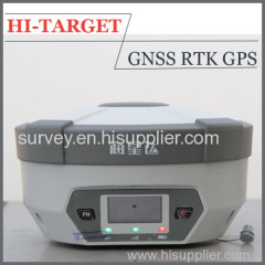
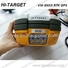
| Model No.: | V30 |
|---|---|
| Means of Transport: | Ocean, Air, Land |
| Condition: | New |
| Certification: | CE,FC |
| Channel: | 220 |
| Signal from: | GPS,BDS,GLONASS,Galileo,SBAS,QZSS |
| Horizontal accuracy(RTK): | 8mm+1ppm RMS |
| Vertical accuracy(RTK): | 15mm+1ppm RMS |
| Horizontal accuracy(Static): | 2.5mm+0.5ppm RMS |
| Vertical accuracy(Static): | 5mm+0.5ppm RMS |
| Production Capacity: | 1000 Set/Quater |
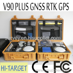
| Packing: | Natural package |
| Delivery Date: | Within 15 working days after payment confirmed |
Product Description
Geodetic Survey RTK GPS receiver for sale
The V30 GNSS RTK system is designed to meet high quality standards at an affordable price. It is outstanding in its class, with a rugged design and user-friendly functions.
*Specification of the RTK GPS receiver:
• 220 Channels
• Advanced Pacific Crest Maxwell 6 Custom Survey GNSS Technology
• High precision multiple correlator for GNSS pseudo range measurements
• Unfiltered, unsmoothed pseudo range measurements data for low noise, low multipath error, low time domain correlation and high dynamic response
• Very low noise GNSS carrier phase measurements with<1 mm precision in a 1 Hz bandwidth
• Signal-to-Noise ratios reported in dB-Hz
• Proven Pacific Crest low elevation tracking technology
Satellite signals tracked simultaneously
GPS: Simultaneous L1C/A, L2C, L2E, L5
GLONASS: Simultaneous L1C/A, L1P, L2C/A (GLONASS M only), L2P
SBAS: Simultaneous L1 C/A, L5
Galileo: Simultaneous L1 BOC, E5A, E5B, E5AltBOC
BDS: B1, B2
QZSS: L1 C/A, L1 SAIF, L2C, L5
Accuracy of the geodetic survey RTK GPS receiver:
Static and Fast Static GNSS surveying
Horizontal: 2.5mm+0.5ppm RMS
Vertical: 5mm+0.5ppm RMS
Post Processing Kinematic
(PPK / Stop & Go) GNSS surveying
Horizontal: 1cm+1ppm RMS
Vertical: 2.5cm+1ppm RMS
Initialization time: typically 10 minutes for base while 5 minutes for rover
Initialization reliability: typically > 99.9%
RealtimeKinematic(RTK) surveying
Horizontal: 8mm+1ppm RMS
Vertical: 15mm+1ppm RMS
Initialization time: typically < 8 seconds
Initialization reliability: typically > 99.9%
Code Differential GNSS positioning
Horizontal: 25cm+1ppm RMS
Vertical: 50cm+1ppm RMS
SBAS: 0.50m Horizontal, 0.85m Vertical
Hardware Information:
Physical
Dimensions (W x H): 19.50cm x 10.40cm(7.68 in x 4.09 in)
Weight: 1.3kg (2.86lb) with internal battery, internal radio, standard UHF antenna
Operating temperature: -45℃to +65℃ (-49℉ to +149℉)
Storage temperature: -55℃ to +85℃ (-67℉ to +185℉)
Humidity: 100%, considering
Water/dustproof: IP67 dustproof, protected from temporary immersion to depth of 1m (3.28ft).
Shock and Vibration: Designed to survive a 3m(9.84ft) natural fall onto concrete.
Electrical
Power 6V to 28V DC external power input
Power consumption 2.5W
Automatic Switching between internal power and external power
Rechargeable, removable 7.4V, 5000mAh Lithium-Ion battery in internal battery compartment
Internal battery life
Static 13 - 15 hours
RTK Rover (UHF/GPRS/3G) 10 - 12 hours
RTK Base 8 - 10 hours
I/O interface
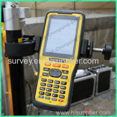
1 x Bluetooth
1 x standard USB2.0 port
2 x RS232 serial port
2 x DC power input (8-pin & 5-pin)
*Contact US: