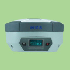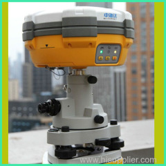
GNSS RTK GPS Receviver for Land Survey
| Min. Order: | 1 Set/Sets |
|---|---|
| Trade Term: | FOB,CFR,CIF,CIP,CPT,EXW |
| Payment Terms: | L/C, T/T, WU |
| Supply Ability: | 100000 sets annual |
| Place of Origin: | Chongqing |
Company Profile
| Location: | Chongqing, China (Mainland) |
|---|---|
| Business Type: | Manufacturer, Trading Company, Agent |
| Main Products: | GPS, Total Station, Echo Sounder, Borehole Camera, Water Level Indicator |
Product Detail
| Model No.: | V30 |
|---|---|
| Means of Transport: | Ocean, Air, Land |
| Type: | Others |
| Certification: | CE |
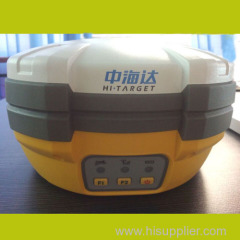
| Brand Name: | HI-TARGET |
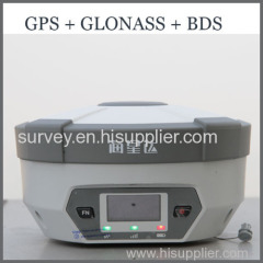
| Support Satellite: | GLONASS,GPS,BDS,CALILEO |
| Channels: | 220 |
| Horizontal Accuracy(static): | 1cm+1ppm |
| Vertical Accuracy(static): | 2.5+1ppm |
| Power: | 6V/28V DC |
| Meterial: | Nano environmental protection material |
| Dust/water Proof: | IP67 |
| Anti-shock: | 1.5m free fall |
| Production Capacity: | 100000 sets annual |
| Packing: | Natural package |
| Delivery Date: | Within 10 working days after confirmed |
Product Description
***Main features:
Multi-constellation tracking
220 tracking channels.
Supports GPS, GLONASS, GALILEO, BDS, SBAS.
NGS approved GNSS antenna.
Intelligent operation
Equipped with a smart speaker guiding the whole operation.
Multi one-button functions make fieldwork easier, such as auto base setup by one button, the rover can get fix solution once it is turned on.
Diversify RTK application
The transceiver UHF radio enables the working mode to be switchable between base and rover.
2-watt HI-TARGET internal UHF radio and 2-watt Pacific Crest TrimTalk© internal UHF radio are optional. Pacific Crest TrimTalk© internal UHF radio is compatible with other radios.
Removable internal UHF radio enables users to fix or exchange simply.Built-in GPRS/GSM/3G module ensures that the V30 works perfectly with network RTK positioning.
Optional transceiver UHF radio
Seamless operation in CORS system
Long-life battery
Powered by 5000mAh Li-ion battery.
Static working time 13 - 15 hours.
RTK Rover (UHF/GPRS/GSM) working time 10 - 12 hours.
RTK Base working time 8 - 10 hours.
Rugged and unique design
IP67 dust/water protection.
Withstands 3-meter natural fall onto concrete.
Rapid tracking and perfect avoidance or reduction of obstruction and multipath effect to ensure superior positioning capability.
***MEASUREMENTS
• 220 Channels
• Advanced Pacific Crest Maxwell 6 Custom Survey GNSS Technology
• High precision multiple correlator for GNSS pseudo range measurements
• Unfiltered, unsmoothed pseudo range measurements data for low noise, low multipath error, low time domain correlation and high dynamic response
• Very low noise GNSS carrier phase measurements with<1 mm precision in a 1 Hz bandwidth
• Signal-to-Noise ratios reported in dB-Hz
• Proven Pacific Crest low elevation tracking technology
Satellite signals tracked simultaneously
GPS: Simultaneous L1C/A, L2C, L2E, L5
GLONASS: Simultaneous L1C/A, L1P, L2C/A (GLONASS M only), L2P
SBAS: Simultaneous L1 C/A, L5
Galileo: Simultaneous L1 BOC, E5A, E5B, E5AltBOC
BDS: B1, B2
QZSS: L1 C/A, L1 SAIF, L2C, L5
***POSITIONING PERFORMANCE
Static and Fast Static GNSS surveying
Horizontal: 2.5mm+0.5ppm RMS
Vertical: 5mm+0.5ppm RMS
Post Processing Kinematic
(PPK / Stop & Go) GNSS surveying
Horizontal: 1cm+1ppm RMS
Vertical: 2cm+1ppm RMS
Initialization time: typically 10 minutes for base while 5 minutes for rover
Initialization reliability: typically > 99.9%
RealtimeKinematic(RTK) surveying
Horizontal: 8mm+1ppm RMS
Vertical: 15mm+1ppm RMS
Initialization time: typically < 8 seconds
Initialization reliability: typically > 99.9%
Code Differential GNSS positioning
Horizontal: 25cm+1ppm RMS
Vertical: 50cm+1ppm RMS
SBAS: 0.50m Horizontal, 0.85m Vertical
***HARDWARE
Physical
Dimensions (W x H): 19.50cm x 10.40cm(7.68 in x 4.09 in)
Weight: 1.3kg (2.86lb) with internal battery, internal radio, standard UHF antenna
Operating temperature: -45℃to +65℃ (-49℉ to +149℉)
Storage temperature: -55℃ to +85℃ (-67℉ to +185℉)
Humidity: 100%, considering
Water/dustproof: IP67 dustproof, protected from temporary immersion to depth of 1m (3.28ft).
Shock and Vibration: Designed to survive a 3m(9.84ft) natural fall onto concrete.
Electrical
Power 6V to 28V DC external power input
Power consumption 2.5W
Automatic Switching between internal power and external power
Rechargeable, removable 7.4V, 5000mAh Lithium-Ion battery in internal battery compartment
Internal battery life
Static 13 - 15 hours
RTK Rover (UHF/GPRS/3G) 10 - 12 hours
RTK Base 8 - 10 hours
I/O interface
1 x Bluetooth
1 x standard USB2.0 port
2 x RS232 serial port
2 x DC power input (8-pin & 5-pin)
***COMMUNICATION AND DATA STORAGE
GPRS/GSM or 3G
Fully integrated, fully sealed internal GPRS/GSM or 3G
Network RTK (via CORS) range20-50km
HI-TARGET internal UHF radio (standard)
Frequency: 460 MHz with 116 channels
Transmitting Power: 0.1W, 1W, 2W adjustable
Transmitting Speed: Up to 19.2Kbps
Working Range: 3~5Km typical, 8~10km optimal
Pacific Crest XDL micro Internal UHF Radio
Frequency: 403~473 MHz
Transmitting Power: 0.5W, 1.0W, 2.0W adjustable
Transmitting Speed: Up to 19.2Kbps
Support most of radio communication protocol
Working Range: 3~5km typical, 8~10km optimal
HI-TARGET External UHF radio (standard)
Frequency: 460 MHz with 116 channels
Transmitting Power: 5W, 10W, 20W, 30W adjustable
Transmitting Speed: Up to 19.2Kbps
Working Range: 8~10Km typical, 15~20km optimal
Pacific Crest ADL Vantage Pro External UHF radio
Frequency: 390~430 MHz or 430~470 MHz
Transmitting Power: 4W to 35W adjustable
Transmitting Speed: Up to 19.2Kbps
Support most of radio communication protocol
Working Range: 8~10Km typical, 15~20km optimal
Support other external communication device
For example, external GSM modem.
Data storage
64MB internal memory
Data formats
(1Hz positioning output, up to 50 Hz - depends on installed option)
CMR: sCMRx, CMR, CMR+input and output
RTCM: RTCM 2.1, 2.2, 2.3, 3.0, 3.1 input and output
Navigation outputs ASCII: NMEA-0183 GSV, AVR, RMC, HDT, VGK, VHD, ROT, GGK, GGA, GSA, ZDA, VTG, GST, PJT, PJK, BPQ, GLL, GRS, GBS
Navigation outputs Binary: GSOF
1 Pulse Per Second Output
***Contact Information: