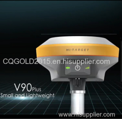
hi-target gps rtk V90 gps rtk
| Min. Order: | 1 Set/Sets |
|---|---|
| Trade Term: | FOB,CFR,CIF,CIP,EXW |
| Payment Terms: | Paypal, L/C, T/T, WU |
| Supply Ability: | 100 pcs per month |
| Place of Origin: | Chongqing |
Company Profile
| Location: | Chongqing, China (Mainland) |
|---|---|
| Business Type: | Manufacturer, Trading Company |
| Main Products: | Water Finder Metal Finder Underground Measuring Instrument Underwater Metal Detector, GPS GNSS RTK SYSTEM, Geological Instrument, Gnss Rtk Gps Base And Rover |
Product Detail
| Model No.: | V90 Plus |
|---|---|
| Means of Transport: | Ocean, Air, Land |
| Brand Name: | Hi-Target |
| weighs: | 950g |
| Diameter: | 153mm x Height 83mm |
| Production Capacity: | 100 pcs per month |
| Packing: | Wooden box |
| Delivery Date: | 15 days after order confirmation |
Product Description
V90 PLUS GNSS RTK SYSTEM
With a hi-tech, fully integrated design, the conveniently sized V90Plus is one of the most flexible choices for any measuring task. Built-in Linux3.2.0 operating system, pre-loaded multiple smart applications such as tilt surveying, electronic bubble calibration, NFC and voice DIY, V90Plus GNSS system provides surveyor industry-leading GNSS solutions.
Small and lightweight
· Only weighs 950g.
· Measures Diameter 153mm x Height 83mm.
Multi-constellation Tracking
· 220 tracking channels
· Supports GPS, GLONASS, GALILEO, BDS, SBAS
· NGS approved full-band GNSS antenna
Smart Application
· Offers tilt survey with a maximum tilt angle of 30 degrees.
· Supports electronic bubble calibration
· The internal NFC module makes Bluetooth communication quick and easy.
· Intelligent voice assistance guides field operations. Voice can be DIY.
· Standard Rinex data and HI-TARGET raw data recorded simultaneously.
Optional Transceiver UHF Radio
· The transceiver UHF radio enables switchable working modes between base and rover.
· Three types of internal UHF radio provide different frequencies based on users requirements. The Pacific Crest TrimTalk© internal UHF radio is compatible with other radios.
Multi-network Connection
· Supports GPRS, GSM and WCDMA
· Supports WIFI
Powerful Battery
· Powered by high-capacity (5000mAh) Li-ion battery to ensure full day operation
Rugged Design
· IP67 dustproof and waterproof
· Able to survive a 3-meter natural fall onto concrete
| Technical parameters |
Satellite Signals Tracked Simultaneously
220 Channels
GPS^….. Simultaneous L1C/A, L2C, L2E, L5
GLONASS^^…..Simultaneous L1C/A, L1P, L2C/A (GLONASS M only), L2P
SBAS^^^^. Simultaneous L1 C/A, L5
Galileo^^^... Simultaneous L1 BOC, E5A, E5B, E5AltBOC
BDS^^^..^.^^^^^…. B1, B2
QZSS^^^^.. L1 C/A, L1 SAIF, L2C, L5
POSITIONING PERFORMANCE
Static and Fast Static GNSS Surveying
Horizontal^^^^2.5mm+0.5ppm RMS
Vertical^^^^^. 5mm+0.5ppm RMS
Post Processing Kinematic (PPK / Stop & Go) GNSS Surveying
Horizontal^^^^….. 25px+1ppm RMS
Vertical^^^^^ 62.5px+1ppm RMS
Initialization time^….Typically 10 minutes for base while 5 minutes for rover
Initialization reliability^Typically > 99.9%
Real Time Kinematic (RTK) Surveying
Single Baseline
Horizontal^^^^….. 8mm+1ppm RMS
Vertical^^^^^. 15mm+1ppm RMS
Network RTK
Horizontal^^^^….. 8mm+0.5ppm RMS
Vertical^^^^^.. 15mm+0.5ppm RMS
Initialization time^..…Typically < 8seconds
Initialization reliability^.Typically > 99.9%
Code Differential GNSS Positioning
Horizontal^^^^…. 625px+1ppm RMS
Vertical^^^^^… 1250px+1ppm RMS
SBAS ^… 0.50m Horizontal, 0.85m Vertical
HARDWARE
Physical
Dimensions (W x H)^.153mm x 83mm (6.02inch x 3.27inch)
Weight^…950g (2.09lb) without internal battery
Operating temperature^…. -40℃to +65℃ (-40℉ to +149℉)
Storage temperature^^. -40℃ to +75℃(-40℉ to +167℉)
Humidity^^^^…. 100%, considering
Water/dustproof^^^.. IP67 dustproof, protected from temporary immersion to depth of 1m (3.28ft).
Shock and vibration^^…Designed to survive a 3m(9.84ft) natural fall onto concrete.
Electrical
Power 6V to 28V DC external power input
Power consumption ≤3.5W
Automatic switching between internal power and external power
Rechargeable, removable 7.4V, 5000mAh Lithium-ion battery in internal battery compartment
Internal Battery Life
Static 12hours
RTK rover (UHF/GPRS/3G) 8-10 hours
RTK base 8 hours
I/O Interface
1 xBluetooth, NFC
1 x standard USB2.0 port
1 x TNC antenna connector
1 x RS232 serial port
1 x DC power input (5-pin)
Tilt Survey System
Electronic Bubble
COMMUNICATION
Network Communication
Fully integrated, fully sealed internal WCDMA, compatible with GPRS, GSM
Wifi frequency is 2.4G, supports 802.11b/g/n protocol
Network RTK (via CORS) range20-50km
HI-TARGET Internal UHF Radio(Standard)
Frequency… 450~470MHz with 116 channels
Transmitting power…0.5W, 1W, 2W adjustable
Transmitting speed^….9.6Kbps, 19.2Kbps
Working range^^.3~5km typical, 8~10kmoptimal
Pacific Crest XDL Micro Internal UHF Radio
Frequency^^^^^….403~473MHz
Transmitting power^^^ 0.5W, 2W adjustable
Transmitting speed^^….. Up to 19.2Kbps
Support most of radio communication protocol
Working range^^^^… 3~5km typical, 8~10km optimal
HI-TARGET External UHF Radio (Standard)
Frequency^^ 460MHz with 116 channels
Transmitting power^. 5W, 10W, 20W, 30W adjustable
Transmitting speed^^… Up to 19.2Kbps
Working range^^^…. 8~10km typical, 15~20km optimal
Pacific Crest ADL Vantage Pro External UHF Radio
Frequency…. 390~430MHz or 430~470MHz
Transmitting power….. 4W to 35W adjustable
Transmitting speed^^….. Up to 19.2Kbps
Support most of radio communication protocol
Working range…. 8~10km typical, 15~20km optimal
SYSTEM CONFIGURATION
System
Data storage^^^…16GB Internal storage (Support up to 32GB external SD card)
Record GNS and RINEX format simultaneously
Data Formats
1Hz positioning output, up to 20Hz
CMR: CMR, CMR+, sCMRx input and output
RTCM: RTCM 2.1, 2.3, 3.0, 3.1, 3.2 input and output
Navigation outputs ASCII: NMEA-0183 GSV, AVR, RMC, HDT, VGK, VHD, ROT, GGK, GGA, GSA, ZDA, VTG, GST, PJT, PJK, BPQ, GLL, GRS, GBS
Navigation outputs binary: GSOF

