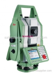
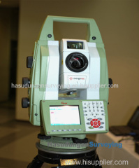
The new Leica Nova MS50 1" Multistation combines the functionality of an
imaging total station and 3D laser scanner into one instrument. Add
robotic functionality and GNSS connectivity as options. Best of all,
Leica's MultiWorx plug-in for AutoCAD and Civil 3D allows drafters and
designers to work with the rich 3D point clouds in a familiar CAD
environment. This greatly simplifies the process of creating your survey
deliverables.
FEATURES:
PRECISE LONG-RANGE SCANNING
● 1000 pts/sec up to 300 m
● Scan range up to 1000 m
● Millimetre scan precision
FAST PINPOINT R2000 EDM
● Reflectorless range beyond 2000 m
● Significantly reduced measurement times
WIDE ANGLE OVERVIEW CAMERA
● Target acquisition with 20 Hz live video stream
● Simple and comprehensive image-assisted
documentation
● Automatic capture of panoramic images
HIGH RESOLUTION TELESCOPE CAMERA
● 30x magnification for high resolution
images and precision target acquisition
● Automatic focussing
ROBUST IP65 DESIGN
● Highest protection rating in the industry
● Withstands MIL standard blowing rain test
IN-FIELD POINT CLOUD PROCESSING
● Automatic point cloud registration
3D point cloud viewer
● On-board surface modelling
ULTRA-DYNAMIC AUTOMATION
● Best-in-class in speed and acceleration
● Automatically find prisms with PowerSearch
● Maximised service intervals
All functions, including precision 3D scanning, extensive and precise
total station capabilities, digital imagery and GNSS connectivity are
now brought together in the Leica Nova MultiStation. A revolutionary
solution with advanced measuring technology that provides unchallenged
accuracy and quality, yet is easy to use for an unprecedented range of
applications. The capabilities of the Leica Nova Multistation are truly
comprehensive and second to none.
The Leica Nova MS50
integrates 3D point cloud measurements into a regular survey workflow.
This lets you collect and visualise your topographic survey data
together
with detailed high-precision scans. Save time by checking
your data for integrity and relevance and avoid costly reworking or
returns to the field. Benefit from better decisions with richer and
more detailed data.
The Leica Nova MS50 features an overview
camera and a telescope camera with 30x magnification and autofocus.
State-of-theart image processing technology delivers
live fluid
video streaming of highest image quality. The imaging capabilities of
the Leica Nova MS50 open up new opportunities of operating the
MultiStation in an almost infinite range of applications.


